Esri- GeoInquiries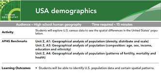
GeoInquires are ready-made, 15-minute hands-on activities that are linked to standards-based concepts. These one-stop shop lessons include standards, learning outcomes, and give teachers the opportunity to push student thinking to a higher level. Teachers can use the projector to present the materials whole class or students can access the maps and layers on their own device. These GeoInquiries could be used in all curriculum areas.
*No account is needed for this activity. Story Map Tour- ArcGIS
Story Map Tour is available via ArcGIS. It allows user to create and present interactive linear, place-based narratives. Geo-locations can include videos, images, text, and links. Readers can explore the story map sequentially or using the browsing carousel.
*No account is needed to view story maps from the gallery. Accounts are needed to to build and create using ArcGIS online software, but free education accounts can be accessed through your district's educational technology department. Check out the ESRI Storytelling with Maps Contest. Students can enter their story maps in the competition April 4-May 23 2017. Google Earth- Placemarks and Tours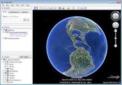
Google Earth is a geobrowser that uses satellite and aerial imagery to represent the earth three dimensionally. Google Earth has many functions, one being that users can use placemarks to build tours to create an interactive story map. Kids of all ages can use Google Earth to explore mapping and the world around them.
*Accounts are not required for Google Earth, but the app needs to be installed on the device. Tour Builder with Google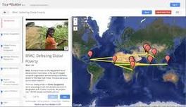
Originally created as a tool for veterans to record their military service, Tour Builder is a tool to explain places you've visited and the story that goes along with it. Tour builder gives users the opportunity to place pins on a Google Earth Map and link pictures, text, and video to share your story and experiences.
*Google accounts are required to create a story map using Tour Builder. |
Uses:
1. To create story maps using different platforms and formats
2. Share stories 3. Content integration Limitations:
1. Devices needed
2. Accounts may be required 3. Internet required for most platforms Documentation:
GeoInquiries Example
Links:
GeoInquiries
http://edcommunity.esri.com/Resources/Collections/geoinquiries Story Map Tour- ArcGIS https://storymaps.arcgis.com/en/ Google Earth Google Earth Information Website https://www.google.com/earth/ Google Earth for Chromebook: http://googleearthforchromebook.com/ Google Earth Navigation: https://www.google.com/earth/learn/beginner.html#tab=navigation Google Earth Placemarks and Tours: https://www.google.com/earth/learn/beginner.html#tab=placemarks-and-tours Google Earth Tour Guide: https://www.google.com/earth/learn/beginner.html#tab=tour-guide Tour Builder with Google https://tourbuilder.withgoogle.com/ Last edited by: Danae and Chandra
3/2/17 | ||||
EdTech

Our mission is to improve teaching and learning through the use of appropriate technologies,
supporting students in their progress toward college-, career-, and citizenship-readiness.

Original content distributed on this website is licensed under a
Creative Commons Attribution-Noncommercial-Share Alike 3.0 United States License.